CLEVELAND — Hurricane season is in high gear.
We have 2 major systems that we are watching: Tropical Storm Marco and Tropical Storm Laura. What makes these storms so unique is when they're hitting the Gulf Coast, within 48 hours of one another.
The big question is will either have an impact here? One of the tropical systems may.
First, let’s discuss what’s happening with both storms. Tropical Storm Marco is expected to make landfall along the Gulf of Mexico at some point Monday night. The good news for Marco is it is beginning to weaken as it approaches Louisiana. It is expected to clip portions of New Orleans and Baton Rouge, Louisiana tonight before continuing westward into parts of Texas including parts of Houston Wednesday morning.
As of 4:00 p.m. Monday, it has sustained winds of 40 mph. That is still enough to cause some storm surge and coastal flooding. Some spots could get up to 7 inches of rain. Marco is primarily losing strength because of wind shear. Wind shear is a change of direction with elevation. Think of a building. On the first floor the winds may be 20 mph and moving from East to West. However, by the time you get to the 12th floor, winds may be going from North to South at 40 mph. Hurricanes hate that. Wind shear will destroy tropical systems because the winds are pushing various parts of the storm in different directions. Most Forecasters are expecting Marco to fully fall apart by Wednesday or Thursday as it continues moving into Eastern Texas.
For Ohio, it is Tropical Storm Laura we are going to keep an eye on.
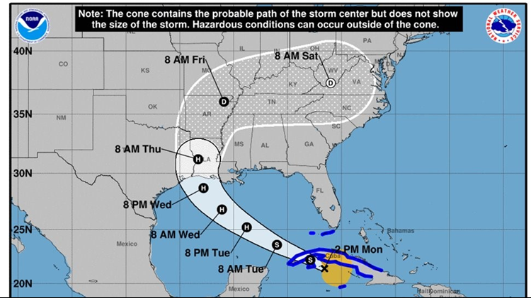
.As of 4:00 p.m, Tropical Storm Laura is near the Cuban coastline and has sustained winds of 60 mph. The National Hurricane Center has Laura moving toward the border of Texas and Louisiana on Thursday and strengthening over the next 24 hours. Why? Laura is expected to move over very warm water in the Gulf. Hurricanes need water that is 80° or warmer and low wind shear to strengthen. Both conditions are expected over the next 48 hours. Laura could slam into the Gulf coast as a Category 2 hurricane – that means it could have winds between 96-110 mph. That will result in significant flooding and storm surge.
Once Laura makes landfall sometime Wednesday night into Thursday, what happens next is still debatable. The models are growing more confident the storm will turn Northward clipping Arkansas and Tennessee. It should then turn Eastward. However how quickly it makes that turn Eastward will impact what we see. Some models are predicting some impacts to our weather on Saturday at the earliest if the storm makes a later turn Eastward. However, because Hurricanes need water temperatures 80°s or warmer to sustain themselves, Laura will not be a Hurricane by the time it could hit our area. However, we could still see impacts in other ways such as some heavy rain showers as well as wind gusts. How much rain and how powerful they will be will all depend on when and if that turn happens.
Bottom line, it is too early to know exactly when and if Laura will impact Northeast Ohio. However, at this point there is a chance that it could.


