
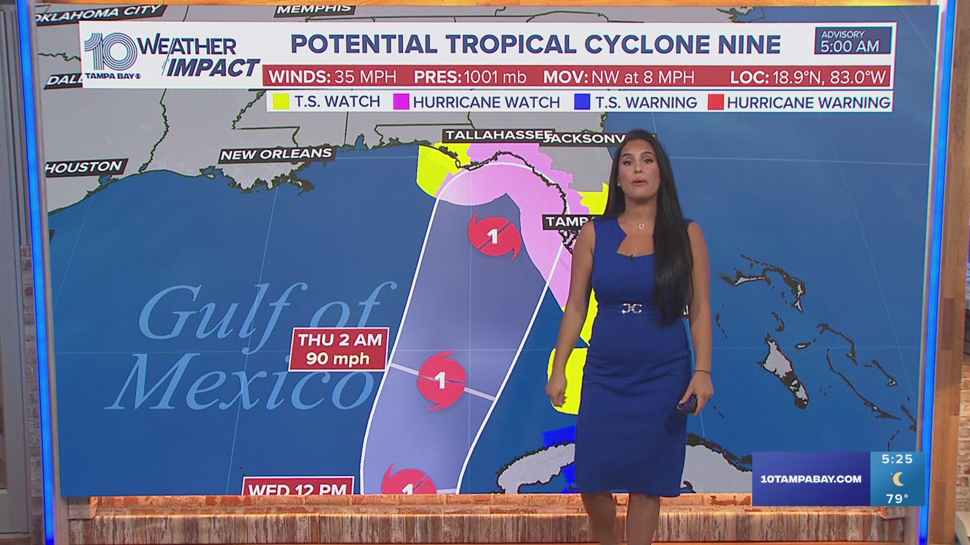
TAMPA, Fla. — The National Hurricane Center says hurricane and storm surge watches have been issued for parts of Florida's Gulf Coast, including the Tampa Bay area, ahead of Potential Tropical Cyclone Nine. It is expected to become the season's next named hurricane.
Hurricane Hunters are investigating the disturbance Tuesday morning. Sometime today, PTC 9 is expected to strengthen into a tropical storm, which will be called Helene.
The NHC issued a cone Monday showing where forecast models expect the system to move. The Tampa Bay area is within the cone of uncertainty.
PTC 9 is expected to "strengthen significantly" over the next few days, becoming a hurricane by Wednesday.
As of the latest advisory, PTC 9 is about 150 miles west of Grand Cayman. It's moving northwest at 9 miles per hour with maximum sustained winds of 35 miles per hour.
Timing: Late Wednesday - early Friday
Late Wednesday is when the first rain bands arrive and severe weather is possible.
Thursday, the system will be parallel to Tampa Bay, passing our area and bringing us a surge. Thursday will be the day with the most severe impacts from the storm, with bands of rain and wind. The surge begins later in the day.
Early Friday, our winds shift out of the southwest as the system leaves our area. Flooding and surge will be the major concern. Conditions return to normal on Saturday with typically showers and heat.
Impacts:
Surge: Pinellas, Hillsborough, and Pasco counties could see 5-8 feet, while northern counties could see 6-10 feet of storm surge
Rain: 4-8 inches possible
Wind: 45-55+ mph sustained winds
Severe Weather: Isolated tornadoes possible, a level 1 risk
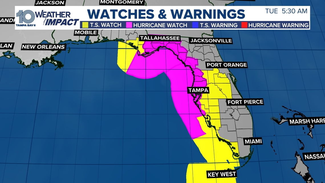
Tropical storm warnings and hurricane watches have been issued for parts of Florida, Mexico and Cuba. A tropical storm watch has been issued for the lower Florida Keys, south of the Seven Mile Bridge.
A storm surge watch has been issued from Indian Pass, Florida, southward to Bonita Beach, including Tampa Bay and Charlotte Harbor.
A hurricane watch has been issued for the Gulf Coast of Florida from Englewood northward and westward to Indian Pass, including Tampa Bay.
A tropical storm watch has been issued for the Gulf Coast of Florida from Indian Pass to the Walton/Bay County Line and from north of Bonita Beach to south of Englewood.

While there is still some uncertainty, models are in better agreement that the system will strengthen while moving northward over the Gulf of Mexico. Although it is too soon to specify the exact location and magnitude, areas along the Florida Gulf Coast should prepare for potential impacts from storm surge, heavy rainfall and strong winds.
Now is the time to make sure your hurricane kit is ready and up to date.
10 Tampa Bay is also monitoring a wave off the west coast of Africa for possible development. This tropical wave is bringing no threat to land or Florida at this time.
What is a Potential Tropical Cyclone?
According to the National Oceanic and Atmospheric Administration, a Potential Tropical Cyclone is what forecasters use to describe "a disturbance that is not yet a tropical cyclone, BUT poses the threat of bringing tropical storm or hurricane conditions to land areas within 48 hours."
If you're not familiar with the term, it may be because it wasn't something forecasters had until 2017. Before the term was implemented, NHC meteorologists weren't allowed to issue a hurricane or tropical storm watch or warning until after a tropical cyclone had formed.
Thanks to advances in forecasting technology, meteorologists now have a more accurate idea about how a tropical cyclone will impact land and can make predictions while the systems are still in the developmental stage.
We will continue to provide the latest information through your 10 Tampa Bay hurricane headquarters.