
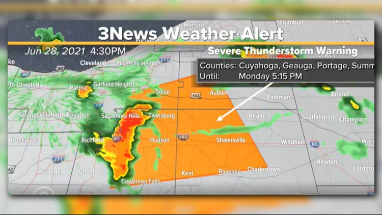
CLEVELAND — The National Weather Service has issued a Severe Thunderstorm Warning for portions of several Northeast Ohio counties on Monday afternoon.
The affected areas include northwestern Portage County, southwestern Geauga County, east central Cuyahoga County, and northeastern Summit County until 5:15 p.m.
At 4;42 p.m., severe thunderstorms were located along a line extending from near Macedonia to Cuyahoga Falls, moving northeast at 25 mph. We could see wind gusts of 60 mph and penny size hail. Expect damage to trees and power lines.
Locations that are impacted include: Akron, Ravenna, Cuyahoga Falls, Kent, Solon, Hudson, Twinsburg, Streetsboro, Macedonia, South Russell, Mantua, Stow, Maple Heights, Aurora, Bedford, Bedford Heights, Munroe Falls, Chagrin Falls, Northfield and Reminderville.
According to the 3News Weather Team, our pattern the next few days will resemble that of the "Sunshine State" with morning sunshine giving way to afternoon bubble-up cumulonimbus clouds and those scattered shower and storm chances.
Highs will be in and around 90 once again on your Tuesday.
This pattern begins to move a bit later this week as we approach the 4th of July weekend. A frontal boundary will sink south helping to clear this hot, humid, and stormy pattern out. Until then, daily hit-or-miss downpours can be expected.
Once the front clears sometime around Friday, cooler and drier air will push south into Ohio. In fact, much of the eastern USA will cool down into the July 4th weekend.