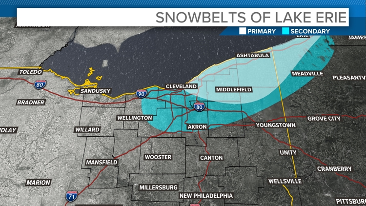
CLEVELAND — In the WKYC viewing area, the primary and secondary snowbelts are regions usually impacted by lake-effect snow due to their closeness to Lake Erie.
Primary Snowbelt
The primary snowbelt lies closest to the lake, primarily in eastern Cuyahoga, Lake, Geauga, and Ashtabula counties. These areas experiences the most intense snowfall because cold air masses sweeping over the relatively warmer lake waters pick up moisture and deposit it as snow when they reach land. In the higher elevation such as Geauga County, enhances the snow accumulation. Annual snowfall can exceed 100 inches in some areas!
Secondary Snowbelt
The secondary snowbelt is located further inland, typically including parts of Lorain, Medina, Summit, Portage, and Trumbull counties, and all of Cuyahoga County. While this area also experiences lake-effect snow, the intensity and totals are generally lower compared to the primary snowbelt because of the increased distance from Lake Erie and reduced influence of topography.


Key Factors:
Primary Snowbelt
Proximity to Lake Erie: The primary snowbelt hugs the lake's shoreline. When cold air moves over the warmer, unfrozen waters of Lake Erie, it picks up the moisture. As this air reaches land, it cools rapidly, causing the moisture to condense and fall as snow.
Westerly Winds: Prevailing winds from the west or northwest align perfectly to direct lake-effect snow bands over this area, concentrating snowfall totals.
Secondary Snowbelt: Farther from the Lake
Distance from Lake Erie: The secondary snowbelt lies further inland, meaning the air has had more time to lose moisture and energy before reaching these locations.
Weaker Snowbands: By the time the lake-effect snowbands reach the secondary belt, they are less intense, but they can still bring big-time snow during an intense lake-effect event.
Lake Erie
In early winter, Lake Erie is typically unfrozen, which maximizes moisture available for snowfall. As the lake freezes later in the season, the lake-effect snow shuts off.


