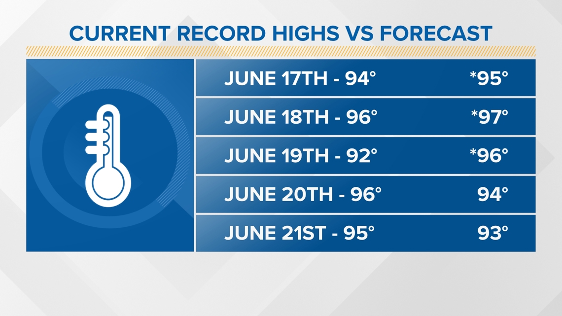
CLEVELAND — It's not even "officially" summer yet, and we have declared WEATHER IMPACT ALERT DAYS because dangerous and potentially record-setting heat is heading to Northeast Ohio.
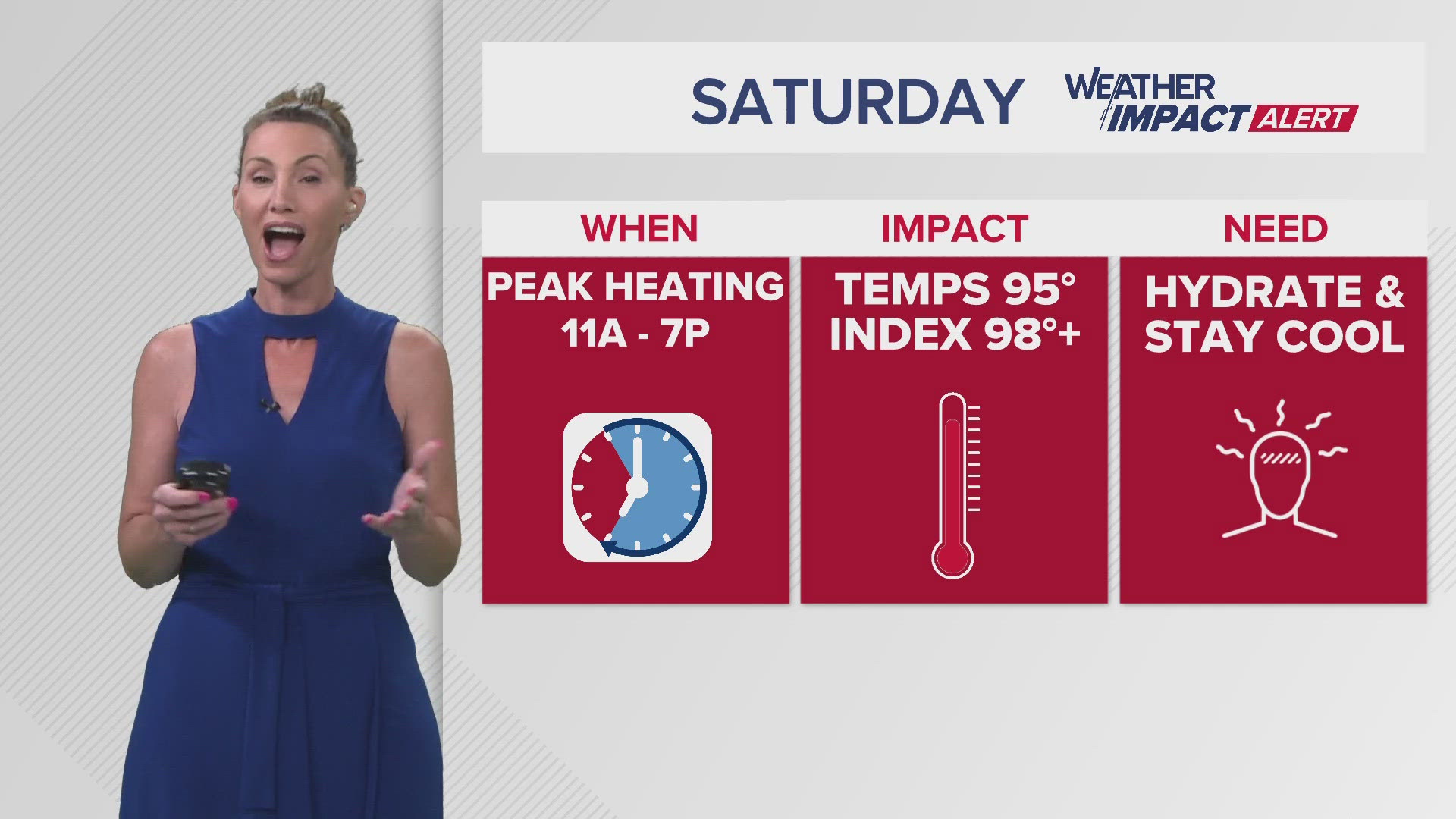
- WHEN: Monday through at least Saturday (June 17-22)
- IMPACT: Numerous days of dangerous heat with highs in the 90s and heat index values of 100 degrees plus possible
- NEED: Prepare ahead! Be sure your air conditioning is working, have fans on hand and plenty of water available. If you DO NOT have AC, make a plan to stay with a family member or friend that does and/or check on cooling center locations near you.
The National Weather Service has issued a Heat Advisory that covers the entire Northeast Ohio region as well north central and Northwest Ohio and Northwest Pennsylvania for Monday through Friday evening. The NWS says "prolonged dangerously hot conditions with heat index values in excess of 100" degrees are possible.
Ironically, the official start of summer is not until Thursday, June 20. This year's Summer Solstice arrives at 4:50 p.m., marking the year's longest day. As we welcome this summer season, we will already be in the middle of a DANGEROUS stretch of heat.


According to AccuWeather, this first widespread dangerous heat wave will impact more than 135 million people next week, stretching from Chicago to Philadelphia.
The record high temperature in Cleveland is 104 degrees, set on June 25, 1988.
Here is a list of the 10 highest recorded temperatures in Cleveland:
- June 25, 1988: 104°F
- July 27, 1941: 103°F
- August 27, 1948: 102°F
- June 28, 1944: 101°F
- September 1, 1953: 101°F
- September 2, 1953: 101°F
- September 3, 1953: 101°F
- July 16, 1988: 101°F
- August 6, 1918: 101°F
- August 19, 1955: 100°F
Let's start with the basics. How is a "Heat Wave" defined/established? According to the National Weather Service (NWS), a heat wave is a period of really hot weather lasting more than two days. With the Weather Impact Alert lasting Monday through Friday, we have already met the criteria established over the years.
The NWS issues a HEAT ADVISORY when the daily heat index (what it feels like with the hot air temperature plus humidity combined) is 100 to 104 degrees. Also, if heat indices are expected to be 94 to 99 degrees for four consecutive days, a heat advisory will also be issued. This will be a no-brainer for next week.
The NWS issues an EXCESSIVE HEAT WARNING when the daytime heat index is 105 degrees or higher and 75 degrees or higher at night for at least 48 hours.
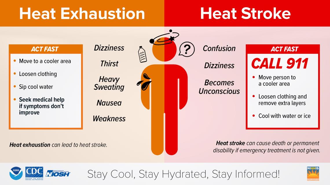
Heat can be extremely draining on your body, which is why it's very important to prepare now. Heat-related illnesses may occur, such as HEAT EXHAUSTION and HEAT STROKE. According to NOAA, during extreme heat, as we expect, your body's ability to cool itself is challenged. This is nothing to fool around with.
Take a look at this graphic and familiarize yourself with symptoms now:


Use this weekend to make sure your AC is running properly. Make sure you also have fans on hand. It wouldn't be a bad idea to purchase some more if you only have a couple or don't have any. Stock up on water. I know this seems like common sense, but waiting until next week when we are dealing with this scorcher is not the proper way to prepare.
During heat waves like this, the Centers for Disease Control and Prevention recommends drinking about 3 liters (12 1/2 cups) of water per day, spaced out, of course. In addition, those working outside should drink at least a cup of water every 20 minutes even if they do not feel thirsty, and skipping breaks is not considered to be safe.
If you DO NOT have AC, this would be the time to start checking with family and friends who do and make arrangements to stay with them until the heat passes. This is important for sensitive groups, which include young children, people on medication and the elderly.
If you don’t have a place to go, check on cooling centers around you. 3News will post information regarding cooling centers as cities announce their plans.
The NWS continues to emphasize the impact of dangerous heat on many other aspects of our day-to-day lives.
According to the NWS, "extreme heat also impacts our infrastructure - from transportation to utilities to clean water and agriculture. High heat can deteriorate and buckle pavement, warp or buckle railway tracks, and exceed certain types of aircraft operational limits. Electricity usage increases as air conditioning and refrigeration units in homes and offices work harder to keep indoors cooler. Transmission capacity across electric lines is reduced during high temperatures, further straining the electrical grid. Water resources are also strained as conventional power plants require large quantities of water for cooling and crops may need increased water consumption, and people increase water consumption to stay hydrated and cool. Heat can have lasting impacts as crops may be damaged, reducing production which leads to short supply and or increased cost to the farmers and consumers."
As we continue to get new data each day, we will keep you updated with any possible changes in the forecast. That being said, next week’s dangerous heat has been consistent throughout all of our data since early this week. It’s time to prepare for our first major heat wave this year.
MORE WEATHER COVERAGE:

