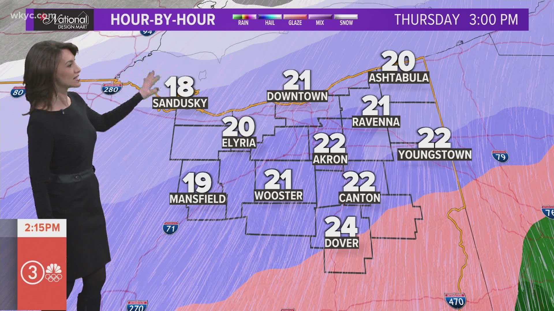
Winter storm timeline: What to expect from school closings to traffic conditions
Here's a guide to everything you need to know as a big winter storm is set to make a major impact across Northeast Ohio.
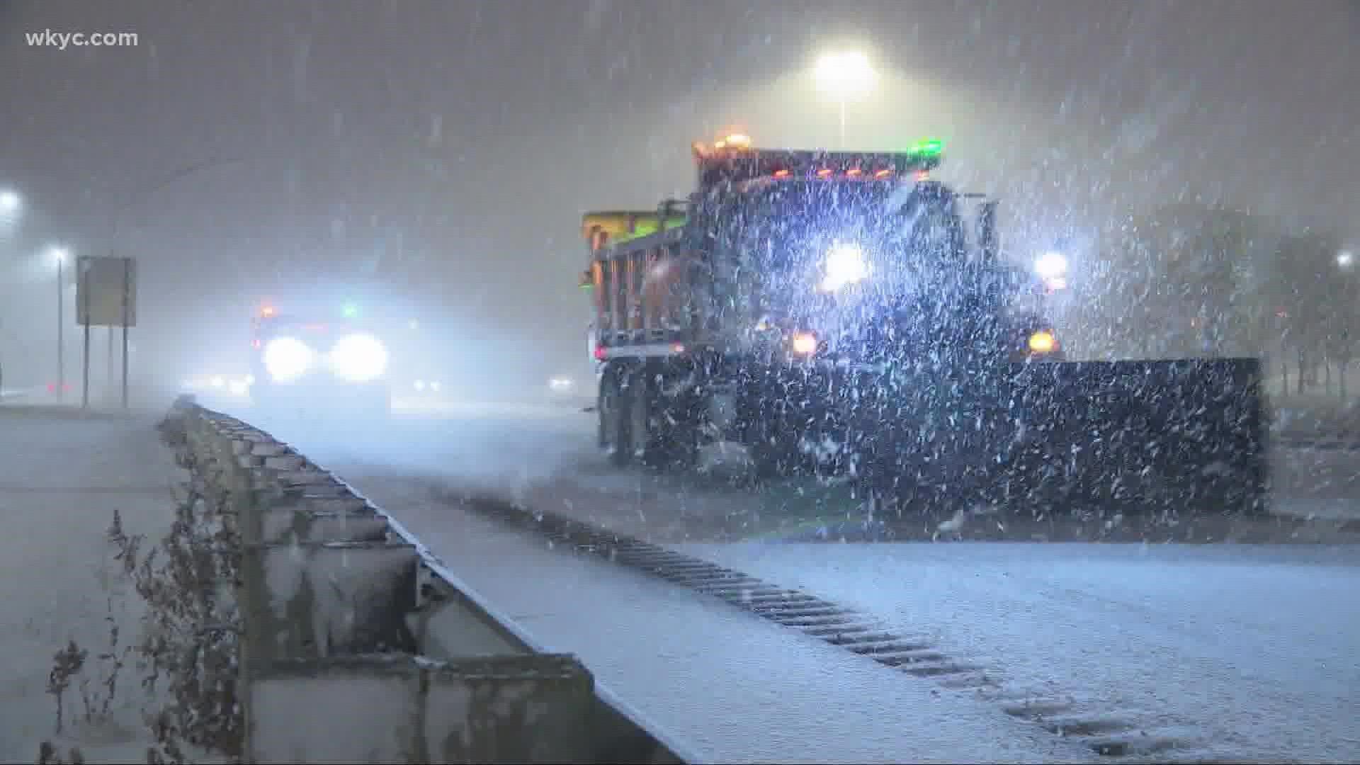
You've been hearing about the incoming winter storm for several days -- and now it is nearly here.
From heavy snow to some ice concerns, this winter storm is expected to pack quite a punch across Northeast Ohio from Wednesday into Friday morning.
We break down everything you need to know about the incoming weather system from to school closing expectations to traffic preparations and more.
Heavy snow The storm's timing
WEDNESDAY
With warm air in place, this storm will start with rainy conditions across all of Northeast Ohio.
“That is going to make a slushy, wet mess,” 3News Chief Meteorologist Betsy Kling says. “The drains are blocked. The water has nowhere to go, so we are talking about widespread standing water.”
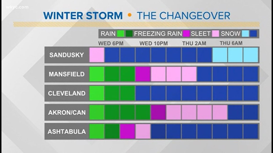
We’re expecting the transition to snow Wednesday night into Thursday morning.
“Western areas will turn to snow first,” Kling says. “The fluff factor will be huge for Toledo. They’re expecting a lot of snow in Toledo – more than we have.”
Here's when you can expect the weather to change in your area:

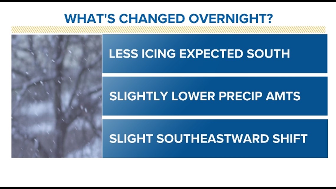
What has changed with the modeling?

THURSDAY
“Thursday is going to be a very difficult day here in Northern Ohio,” Kling warns.
This is when you can expect the heaviest snow. Counties to the north will be hit with the heaviest snow.
FRIDAY
The winter storm finally moves out in the morning, leaving us with bitterly cold temperatures. Highs on Friday are expected to only climb into the upper teens with lows into Saturday morning dipping down to the single digits.
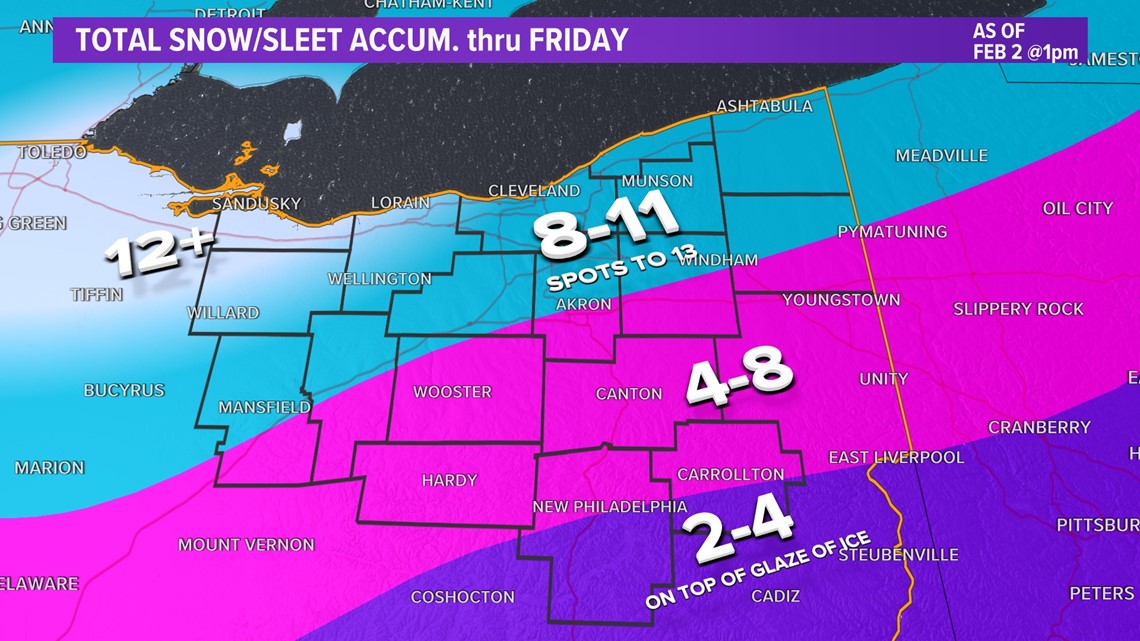
Accumulations Why you shouldn't focus on the numbers
Kling has been urging everybody to not be so focused on the numbers with this storm.
“There’s crazy numbers and they’re going to still change. We have to focus on the impacts,” she says. “No matter if you get 10 inches of snow or you get a third of an inch of ice, you’re going to have huge impacts. …”
3News’ Matt Wintz also shared some changes to the forecast early Wednesday morning.
“We are expecting less icing down towards the south,” he said. “That is fantastic news. Earlier in the week this looked like this was going to be an ice storm for those of you south of Canton. It doesn’t look like that anymore. We’ll likely still have some icing, but not nearly the thickness or the longevity in terms of the freezing rain and sleet that we’ve been seeing in the models over the last couple days. The amount of precip in this system has been slightly lowered. Also, the snow type is expected to be a little bit more moisture-filled. It will be a heavier and wetter snow, so that will cut down on some of the bigger totals because the heavy, wet snow kind of compacts a little bit more. Still expecting a pretty healthy snow all across Northeast Ohio.”

Impacts School closings, traffic concerns, power outages and more
This storm is expected to cause significant travel issues throughout the region, which, of course, means...
SCHOOL CLOSINGS
“Lots of school closings Thursday and Friday,” Kling predicted on Monday.
Is your school closed? CLICK HERE to see the current list of school closings, which is updated in real time once schools announce they're closed.
TRAFFIC
“Travel is going to be tough,” ODOT warned earlier in the week.
How are they preparing?
"During winter storms, ODOT strives to keep roads passable to help ensure that emergency services and essential workers can safely reach their destinations," said ODOT Director Jack Marchbanks. “But even with our crews out in full force, roads will likely be snow and ice-covered, and it will take much longer to travel. Once the storm moves out, our crews will be able to make progress toward getting traffic moving at regular speed."
ODOT also provided a fresh update Wednesday morning to note they will be fully staffed with 300 plow trucks throughout Northeast Ohio with crews working 12-hour shifts.
ODOT says their goal is to have the average traffic speed on primary routes back to within 10 mph of the posted speed limit within two hours after the storm ends. For secondary routes, that goal is four hours.
RELATED: 'Travel is going to be tough': ODOT prepares for high-impact winter storm in Northeast Ohio
Cleveland Mayor Justin Bibb provided a message to residents on the eve of the winter weather blast. "This is not our first storm and it certainly won't be our last. Please have patience for our plow drivers as they work hard to clean our streets around the clock. If you can avoid traveling on the roads, please stay home."
He added that the city will utilize additional plow trucks to deal with the snow in residential areas while the fleet of remaining trucks will clear Cleveland's main streets.
Ohio Gov. Mike DeWine, meanwhile, issued a statement Tuesday morning asking drivers to stay off the roads as much as possible during the winter storm.
The Ohio Turnpike has issued a travel ban for what it calls "high-profile vehicles" from 7 a.m. Wednesday through 12 p.m. Friday. The travel ban covers the entire portion of the Ohio Turnpike and includes mobile home/office trailers as well as boat and horse trailers towed by passenger vehicles or pickup trucks.
If you are out on the roadways and do run into trouble, AAA offered some tips to drivers who get stuck.
POWER OUTAGES
FirstEnergy tells 3News they have crews prepared for any potential power outages that may come from this winter storm.
“We realize the impact of a winter storm remains unclear until it hits the region, and our utility workers are ready to roll if it does cause outages,” Lauren Siburkis of FirstEnergy tells 3News. “In addition to having around-the-clock, all-hands-on-deck coverage during severe weather, FirstEnergy’s utilities in Northeast Ohio have additional resources on standby to assist our line crews with any potential outages that might occur.”
They also released multiple tips for your family to follow in the event of a power outage during the storm, which you can read HERE.
SNOW PARKING BANS
Some communities have activated snow parking bans as a result of the winter storm. That means vehicles in violation by parking on the street could be ticketed and towed. You can see which communities have issued a parking ban with our list HERE.
Important weather tools How you can track the storm as it develops
Below is a list of resources you can use to stay informed throughout the winter storm...
- Live interactive radar: Track the winter storm
- iAlert: List of school closings and delays
- Current weather alerts: See how your county is impacted
- Forecast: See the extended weather outlook
- #3Weather: How to send us your weather pics and videos
- Cleveland snow plow tracker: Check the plowing progress in your neighborhood
- Breaking alerts: Download the free WKYC news app (Android, Apple) to have alerts sent directly to your phone as the winter storm evolves
- Newsletter: Sign up for our free newsletter to have weather updates sent directly to your inbox.
3News has you covered Extended storm coverage
We will be with you throughout the winter storm in a variety of ways.
First, you can follow the progress of the winter storm with our in-depth live blog, which features real-time updates throughout the weather event. That live blog will be published right here on WKYC.com and the free WKYC news app.
We have team coverage on air with a special noon newscast scheduled for Thursday. You can watch our newscasts as follows:
- GO! morning show: 4:30-7 a.m.
- What's New: 5-6 p.m.
- What Matters Most: 6-6:30 p.m.
- Front Row: 7-7:30 p.m.
- What's Next: 11-11:30 p.m.
We will also be sharing lots of updates across social media, so be sure to follow us and subscribe:


